Previous Page
Glaciation

This is an example of scrape marks made as the glaciers
moved south. The view is
looking south. Notice not all the scrapes
are in precisely the same direction.
The different advances of the
glaciers came at slightly different angles.
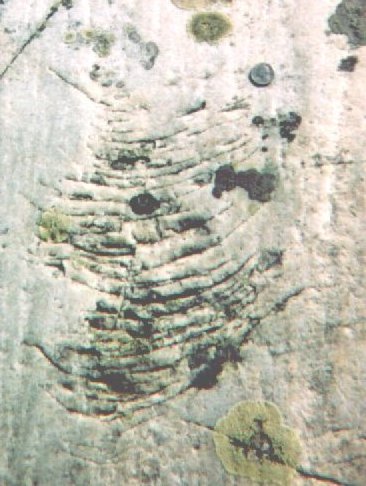
This is an example of "chatter" caused by
glaciation. The glacier moved up in
the picture (south) pushing a rock over the bedrock of the island. The bouncing or
jerking of
the rock caused the marks.
There is a quarter in the upper right of the picture to help one get a sense of
scale.
You may have encountered the phenomena of
"chatter" when writing on the blackboard.
If the chalk is held the wrong way, it can do a kind of skip and bounce across
the board.
Chatter is also a continuing
concern
in machine design. The elastic interaction of the
cutting tool on the material being cut can produce chatter which may result in
tool
breakage and damage to the part being machined.
As a side note, it is worth noting that the south side of the island has quite a bit
of
loose rock in the water. We tried to build a harbor there by making a
crib out of logs
and filling it with rocks in about 1963, or well before the harbor
was blasted.
The ice took it out. There is also a lot of loose rock
just outside of the harbor but all of
that is a result of dynamiting the
harbor. It could be that the rocks on the south side
remained from the
glaciation because the island sheltered them. It would be interesting
to survey other islands in McGregor Bay to see if they also had a preponderance
of loose rock on the south sides.
Isostatic Rebound
All the land in this
area is rising at a rate of abut 1 foot per century relative to the
water in
lake Huron due to Isostatic rebound from the weight of
the glacial ice
melting off the area. This is an important fact to consider when tracing the
routes of
the voyagurs who passed this way from the mid 1600’s to the mid 1800’s because
the water around the island was about 4 feet deeper in the 1600's then in the
2000's.
When looking for canoe routes that is a lot. I explored a Voyageur
route along the
French River with Dave east of Killarnie. It did not look too promising now
but
a couple of feet more water would have made it quite attractive.
This
rebound is from recorder history ('tidal gages'), but is also seen
in elevated beaches. There is some indication that the rate of
rebound
is slowing down, that it was greater shortly after the ice receded.
Some
alternate sources of glaciation information is:
http://en.wikipedia.org/wiki/Post-glacial_rebound
A report by the Natural Resources Canada shows the rebound
around Little Current to be 27 cm (10.6 In) /Century
The title of the report is Apparent Vertical Movement
Over the Great Lakes - Revisited and it is dated November 2001
I can no longer find it on the web.
http://igs.indiana.edu/geology/ancient/freezeframe/index.cfm
Its principal emphasis is further south but it has good info.
http://culter.colorado.edu/~saelias/glacier.html
has information about what causes Ice Ages.
The
Glacial Lakes around Michigan by William R. Farrand, University of
Michigan,
Published in 1988 by the MI Department of Environmental Quality, Geological Survey
Division. This is a good overview of the work of the glaciers in forming the
Great Lakes.
Rev 8/6/12